Hi there! I’m a physics teacher hopping over to help with a tectonics unit we are writing with a non-profit. I have no background in Python but this interface looks amazing.
I’m trying to find roughly how far Africa and South America have moved from their projected positions and locations in Gondwanaland. I hate how some student handouts have just the actual distance between the two continents, and not distances that reflect their change in latitude and longitude and physical movement since they were one mass. Those student rate calculations bother me, because I know it is just based on a straight line between two parts that they think were joined at one point.
I feel like such a cotton-headed-ninny-muggins, to quote the movie Elf, but would someone be willing to help me find these rough distances that the two land masses have actually moved? The top and bottom of the continent movement is totally fine- we have a large class discussion about how the rates and movement is variable based on different factors. The best estimate I’ve found is 6660km from the center of one continent to the other (on average, I know that different segments have moved different ranges).
Fire up GPlates, loading the DataBundleForNovices.gproj Project file located in SampleData/DataBundleForNovices
Drag the *.shp file of the cities/populated places (replace with your choice of cultural data you want to use) into GPlates, if your input data has an attribute called name or something similar, you can tell GPlates to map that attribute to the Name GPlates associates with features by default in the import dialogue. Click ok. This should look something like this:
The go to the menu bar and select Features → Assign PlateIDs. In the following dialogue, select the Muller_etal_AREPS_2016_StaticPolygons as the partioning layer, click next, then select the layer you just loaded as the one to be partitioned, click Next. Click Apply as the last step and let GPlates do its magic.
you have now associated the cultural data with the plates and those features should now move around with the plates.
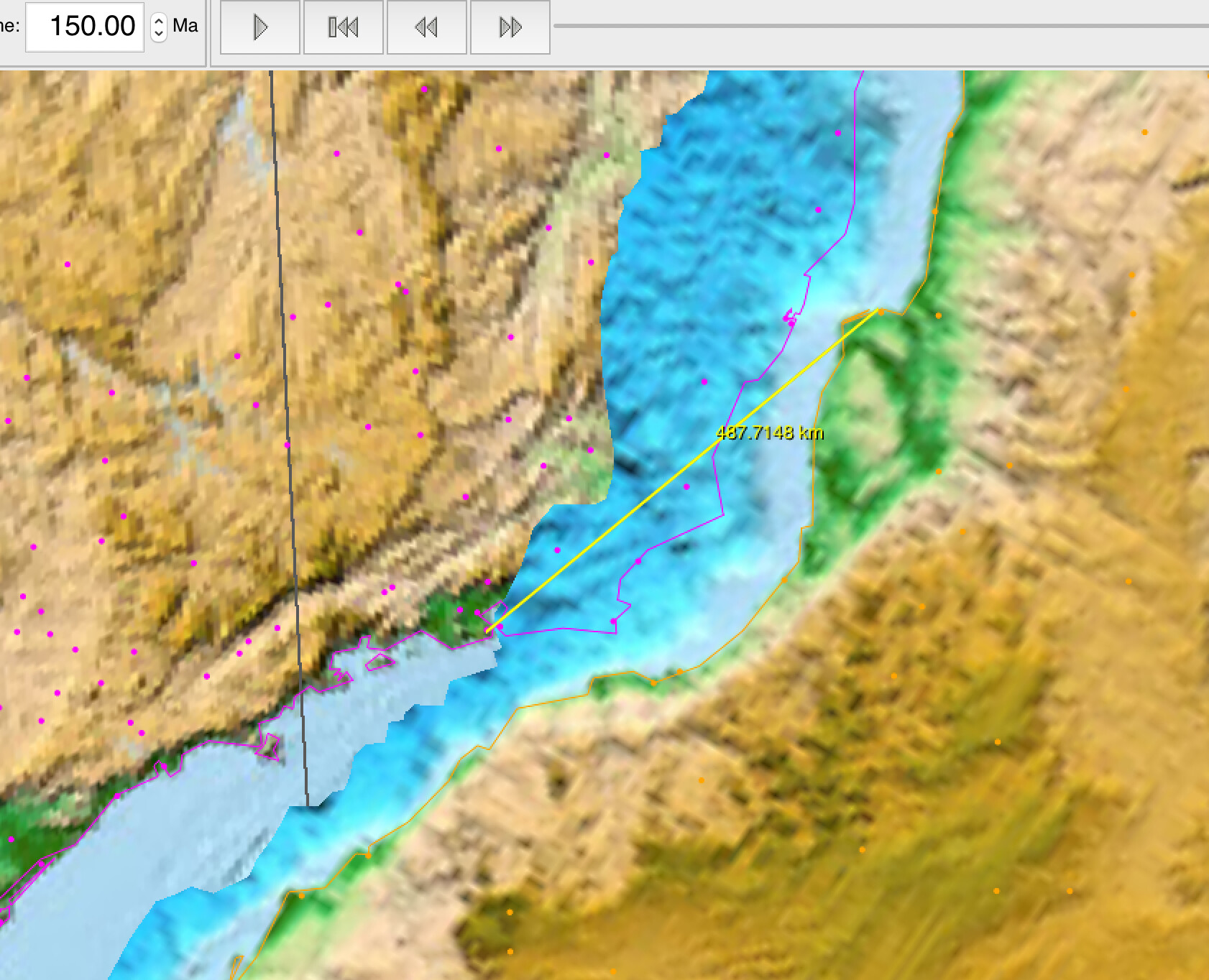
Now you can close the South Atlantic by going back to, say 150 Million years. Click on the measuring tool (looks like a compass or simply press s). Click on a place in Africa and then one in South America - say Luanda and Rio de Janeiro (~500 km, driving distance in the Jurassic):
Then go forward and repeat at any given time you would like to check the distance.
More complicated:
In the main GPlates interface: Use the Kinematics Tool (Menubar → ‘Tools’ → ‘Kinematics Tool’) to compute how a place (you can use the Use focussed feature to utilise the currently selected feature) has moved through time (rates, lat, lon etc)
Use pyGPlates: Compute the distances between features through time
Take a GIS (like QGIS) to compute the centroid of a polygon and then go through the steps above.
The GPlates manuals are probably a good starting place.